Yountville to St. Helena Construction Updates
Stay informed about the latest construction updates on the Napa Valley Vine Trail!
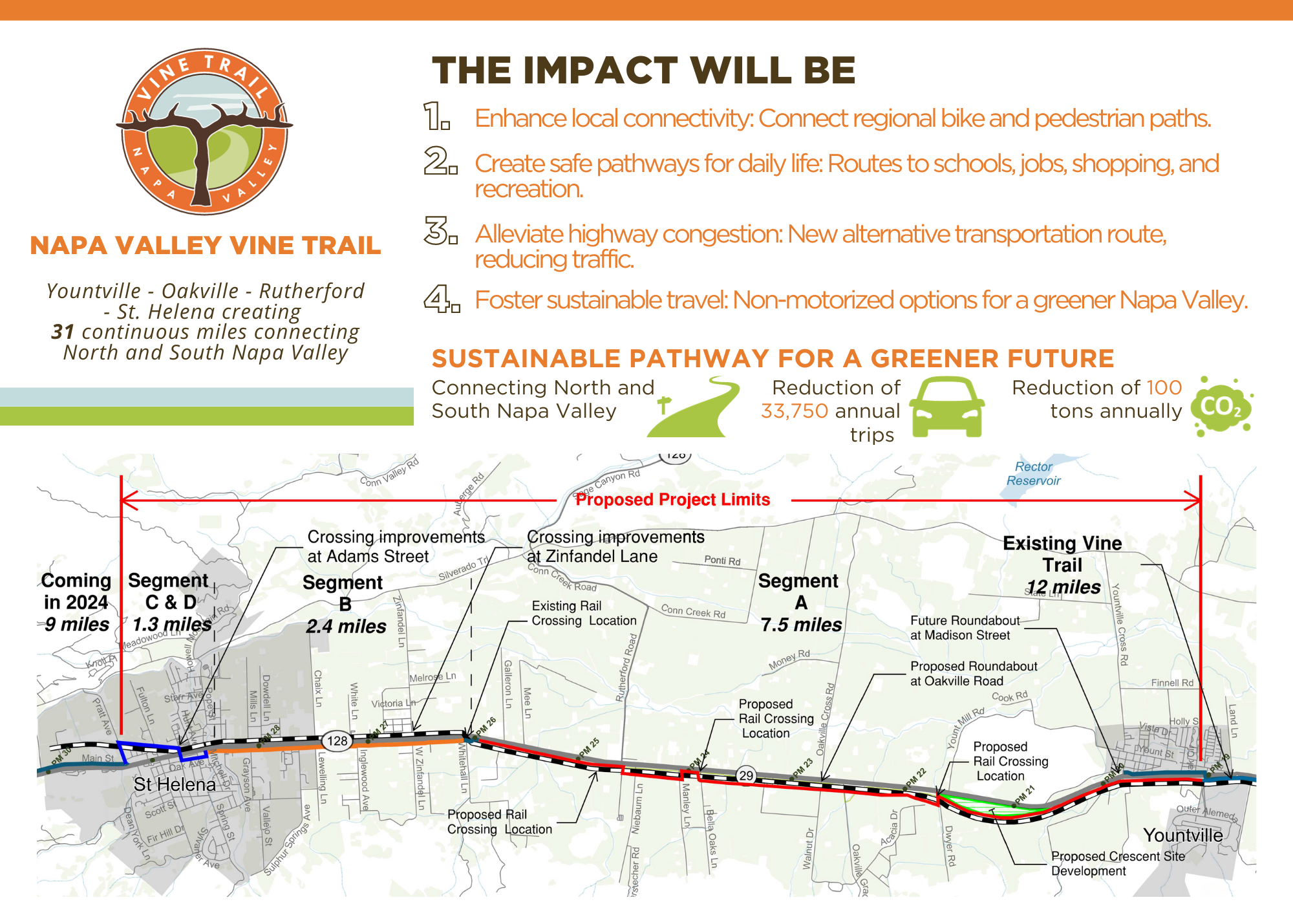
Coming Soon! | Napa Valley Vine Trail | Yountville to St. Helena
Join us at your local town hall meetings to learn about the Yountville to St. Helena VINE TRAIL construction.
Get insights on preliminary route design, environmental and traffic studies, and project timeline. Share your feedback with partners from design and engineering consultants Kimley-Horn and RSA+, County of Napa, City of St. Helena, Town of Yountville, and Napa Valley Vine Trail Coalition.
Since our first round of meetings, we have expanded the environmental and traffic studies to complete the full EIR for CEQA and NEPA. We had expected to be able to share traffic data and more with the community by April, but with this expansion of studies, the data has been delayed. In light of this, we postponed our April meetings to August.
|
Phase 2 |
|
|
|
Date |
Time |
Location |
|
8/19 |
9:30 AM |
|
|
8/20 |
12:00 PM |
Via Zoom |
|
8/21 |
4:00 PM |
|
|
8/22 |
4:00 PM |
|
|
8/23 |
12:00 PM |
Via Zoom |
Unable to attend? Complete our VINE TRAIL Survey instead.
Click the button below to take the survey.
Be Heard: Share Your Comments and Concerns with Us
Click the button below to submit your feedback. Ensure that you choose the topic "Route."
If you're eager for more adventure, take a short ride south to Yountville. There, you'll find the 12-mile VINE TRAIL segment that connects Yountville to Napa.
The Napa Valley Vine Trail is currently in construction on the 5.5 mile segment connecting Vallejo to American Canyon and 9 miles segment connecting St. Helena to Calistoga to be finished this summer 2024.
Lace up your shoes or hop on your bike, and let the adventure begin!
Community Meeting Q&A
1. Is an easement owner afforded same liability protection as a landowner? Specifically, Vine Hill Ranch access road supports significant Ag-related traffic. What liability protections are afforded? 2. What will be incorporated to allow for safe and timely crossing at intersections?
The legal status of traffic crossing the trail is the same as traffic crossing sidewalks to enter businesses or travelling over crosswalks on public streets. Either the landowner of the trail user or both may be at fault in an accident. The indemnity protections of landowners who grant easements do not apply to the general public crossing that easement.
1. Left turn off Niebaum Ln concern 2. Crossing guard location - what, how? 3. Redwood tree safety with trail so close (Pacific Tree Care needs to be included) 4. Ditch and easement needs? 5. Bike track on school grounds with small children 6. Why not trail on east side of tracks? 7. No signs in front of the school
The NVVTC and engineering staff have met with the parcel owner on site to discuss these items. The location of the path relative to the Redwood trees has been established. An arborist will review this and develop design elements to protect the trees. The crossing of the tracks is in design and discussion with the Wine Train and the California Public Utilities Commission and the results will be included in the 65% plans this summer.
Adam Street is VERY narrow and I'm concerned about bikers in that space.
The approach is to create a bike boulevard on these streets. The design will include traffic calming measures, signs and striping to reduce traffic speeds to 20 mph or less and traffic volume to under 1,500 cars per day to make bike riding safer. Additionally, traffic light sequencing will be studied to see if there are ways to make the crossing of Main Street safer.
Any plans to allow for pedestrians to cross safely?
Yes, the design team is working with Caltrans to provide safe crossings across Highway 29 at many intersections within the project limits.
Concerned for loss of personal property and impact on our daily life. Property has been in the family for 6 generations and has active vineyard production.
The NVVTC and County understand your concern and have been working with the agricultural community to protect properties and educate trail users. The Vine Trail Coalition is monitoring issues that arise on the trail on an ongoing basis and coordinating the jurisdictions' efforts to correct these issues.
Concerns with York Creek Bridge - too narrow.
This is indeed a narrow path across the Bridge. It is part of the Saint Helena to Calistoga Project scheduled to be completed this summer. Caltrans approved this minimum width to preserve the historic bridge. Signs will be posted telling bicyclists to dismount to cross the bridge and there will be vertical plastic lane strips to separate the cars from the trail.
Does the trail cross Whitehall Lane?
The Vine Trail will be on the west side of Highway 29 and will cross Whitehall Lane and continue north. It will not cross Highway 29.
Highly concerned about: 1. Block of Adams between Oak and Main where eastbound and westbound traffic can barely pass by each other now - especially trucks and large vehicles. 2. Intersection of Adams/Main where there is high level of fast traffic and cars turning onto Main from Oak often ignore "walk" signs for pedestrians.
The approach is to create a bike boulevard on these streets. The design will include traffic calming measures, signs and striping to reduce traffic speeds to 20 mph or less and traffic volume to under 1,500 cars per day to make bike riding safer. These design elements will be in the 65% plan set, for review by the public this summer.
How about Neibaum Lane and others? How will they make a left safely? There’s a school there.
The Project will include "Yield" or "Stop" signs for trail users at key intersections.
How about Zinfandel Lane?
Yes, the design team is working with Caltrans to provide a safe crossing across Highway 29 at Zinfandel Lane.
How are you going to get property owners to agree to this?
Studies have shown that before a trail is put in, there are usually concerns on the part of property owners or neighbors over crime, real estate values, privacy and liability issues (the "CRPL" four that can cripple a trail's development). These studies also demonstrate that these fears are unfounded. Crime along trails is lower than the area average, real estate values are marginally higher for properties on trails, privacy issues can be minimized through proper design, liability is low in theory and lower in practice around existing trails, and landowners are specifically protected in California by Civil Code section 846. See the link to the 372 trail study on our links page for more!
How big are the landowner signs?
The signs are 11x17" and mounted on a 4' mile marker post, for a total height of just over 6'.
How do we cross 29 to get to path? Also concerns with narrow access at train station.
The plan is to construct a concrete safety barrier between the tracks at the Rutherford Depot and Highway 29. The design team, Caltrans, MTC, and the Napa Valley Transportation Authority are coordinating plans to construct a safe path across Highway 29 at Rutherford Road and Oakville Cross Road as part of the separate Napa Forward project. The designs for both projects are being coordinated.
How do we get information about these other projects?
Contact Kate Miller or Danielle Schmidt at the Napa Valley Transportation Authority or view the website for the Napa Forward project at https://nvta.ca.gov/planning-and-projects/current-projects/napa-valley-forward-intersection/
How many bikes can you fit on the 10’ trail?
Two bike riders can comfortably ride side by side on a 10-foot-wide paved path.
How many people will use the new path?
Approximately 400,000 to 500,000 people use the Vine Trail between Napa and Yountville each year when counted at 3 different location. That means that counts at any single location are 130,000 to 170,000 per year or 350-450 per day.
How much is maintenance?
Currently, the Vine Trail Coalition and the jurisdictions are budgeting $15,000 per mile, per year, adjusted for inflation for routine maintenance. They are also monitoring actual maintenance expenses and will adjust the budgeted amount to match historical costs.
How much will it cost and where will the money come from?
The cost of the Vine Trail is estimated to be $50 million. There are a number of federal and state sources of funding for trails; we hope to create a compelling story to win access to funds for at least half of the project, with fundraising events and capital campaign donations providing the remaining half. To date, we have assisted public agencies to secure $12 million in federal and state funds.
How will the project improve the traffic at the Highway 29 at Madison intersection?
Kimley-Horn and Caltrans staff will work together to make the intersection of Madison and Highway 29 as safe as possible. As the design progresses, the NVVTC will share the plan with the public. Traffic studies are being conducted in April 2024 to inform that design. The results will be included in the 65% plan set, due out for review by the public this summer.
How will the Project prevent people on the path from picking grapes in our vineyards?
The NVVTC will work with property owners on including fencing in the project. The NVVTC has also developed a robust Ag Respect campaign to educate all trail users about the proper etiquette of using the trail including respecting private property.
How will you address our concerns about high-speed bikes colliding with people?
Many studies including Napa County's Vision Zero Plan have shown that 75% of all fatalities and seriously injured bicyclists and pedestrians involve a vehicle, so Bikes and Peds will be much safter on a separated trail. Additionally, the lower speeds and reduced mass of bikes as compared to cars means that accidents between bikes and peds will be much less damaging. There will be accidents but their number and severity will be much less.
If a path user is hurt on the path, how are the adjacent landowners protected from liability?
If the Vine Trail is built on an easement on private property, then the property owner is protected from liability as written in the easement agreement with Napa County. The NVVTC is meeting with property owners and will provide easement agreements for their review and approval.
Is a trail an asset or a liability to Napa Valley?
The trail will be a huge benefit for the community; many studies of existing trails, including several listed on our Resources page, have shown exactly that. Public trails are used extensively by both local residents and visitors, and generate economic benefits on the order of $50 per use. They also have recreational, health, environmental and social benefits that go far beyond monetary and/or commercial value. Over 18,000 students attend schools within a half mile of the Vine Trail.
Is the Project going to include parking at the “Crescent”?
After meeting with property owners and Caltrans staff, the project does not include parking at the "Crescent" on the west side of Highway 29 across from Washington St.
Napanook Road - U turns, intersections turns and Vine Trail will increase the number of accidents. More details, less sales, please.
As the design progresses, the NVVTC will meet with property owners to share the plans being developed to make the Madison Street intersection safe for all users.
Napanook Road - unauthorized or unforeseen parking by cyclists. More details, less sales, please.
The portion of Napanook Road that is parallel to the railroad tracks is a public road. When parking creates an unsafe condition on County maintained roads, the County has placed "No Parking" signs. If there is an unsafe condition on Napanook Road in the future, then County staff will ask the Board of Supervisors to approve a "No Parking" zone.
Niebaum-Manley: 2 separate parcels missing
Engineering staff are researching the property lines and the NVVTC will work with property owners to correctly show the parcels as part of the 65% plan set, due in August.
Oak Avenue - lots of cars, kids and concern about where the bikes will go.
The approach is to create a bike boulevard on these streets. The design will include traffic calming measures, signs and striping to reduce traffic speeds to 20 mph or less and traffic volume to under 1,500 cars per day to make bike riding safer. These design elements will be in the 65% plan set, for review by the public this summer.
Please do not move the trail to the west of the train. Need very attractive fencing on the trail between Fulton and Pratt. We have a 4' fence and lose privacy.
After meeting with the Napa Valley Wine Train, the Vine Trail Coalition and City of Saint Helena staff, the plan is to construct the path on the east side of the railroad tracks between Fulton and Pratt.
Regarding Pratt Ave - my home is on Pratt and I'm very concerned with the proposal. It infringes on the vineyard and the ability to farm it, as well as the driveway and front yard. Will there be a barrier between trail and front yard?
The County and the Vine Trail Coalition have met onsite with this landowner and will be incorporating several design changes to protect the landowner's ability to farm their vineyard, including curb cuts at all the vineyard avenues, moving the trail onto City of Saint Helena property as much as possible, constructing a small retaining wall to accommodate the grade differential between the property and the trail for approximately 70' and conforming the driveways to the new trail elevation. These design changes will be incorporated in the 65% plan set this summer.
The crossing of 29 at Madison is very dangerous. I am concerned that bikes will try to cross there to go to NoYo/R&D/etc. Even a roundabout would not stop 29 traffic in rush hour.
Kimley-Horn and Caltrans staff will work together to improve the intersection of Madison and Highway 29 to make it safe for the increased bike and pedestrian traffic. Traffic studies are being conducted in April to inform that design. The NVVTC will share the plan with the public as part of the 65% plan set.
The proposed trail borders close to my backyard. We will lose privacy, especially if the west-side is being considered. We will have to make major investments in creating a privacy shield which we cannot afford.
After meeting with the Napa Valley Wine Train, the Vine Trail Coalition and City of Saint Helena staff, the plan is to construct the path on the east side of the railroad tracks between Fulton and Pratt.
There are a lot of bicycle races and rides events. Will the Vine Trail be part of these events to take them off the streets?
There are running races on the Vine Trail in the City of Napa and it is likely that there will be running races on this section of the Vine Trail. Any event with more than 50 people needs to have a special event permit from the County, which includes managing all aspects of the event.
There are a lot of old oak trees that are right in the line of the path. Will they be removed?
It is a priority for the NVVTC and County to protect large diameter trees and the design consultant is designing the path around the trees as much as possible. The County will mitigate tree removals. A count of the number of trees to be removed and their mitigation will be included in the 65% plan set and accompanying Environmental documents this summer.
There are concerns with traffic on Napa Nook Road (across Highway 29 from Madison Street). Can the County install “No Parking” signs on Napa Nook Road?
The portion of Napanook Road that is parallel to the railroad tracks is a public road. When parking creates an unsafe condition on County maintained roads, the County has placed "No Parking" signs. If there is an unsafe condition on Napanook Road in the future, then County staff will ask the Board of Supervisors to approve a "No Parking" zone.
What about traffic on streets? Rutherford road, people are passing at 55. These trails seem really close to the road. have you considered traffic calming?
Traffic calming measures will be included in the project. The standard trail is 10 feet of pavement and two - 2-foot-wide gravel shoulders. There are places where the path will be only eight feet of pavement; however, the design team will minimize these. When the path is closer than 20 feet from the travel lanes on Highway 29, the design team will include a concrete safety barrier in the project to separate the trail from the road. The intersections at Madison, Oakville Grade, Oakville Cross Road, Rutherford Road, Zinfandel Lane and the cross streets in Saint Helena will also include upgrades for safety of trail users.
What is the location of the rail fence?
The Napa Valley Wine Train staff said that, in general, a fence will not required between the tracks and path. The engineering consultant may recommend a fence in certain limited situations.
What will happen to path users when the vineyard owners close the path?
When property owners close the path on their property, the NVVTC would like a notification to share with the public so that people can avoid the closure or find a safe route around the closure.
When a landowner closes their portion for ag use/safety, how is traffic rerouted safely?
When a property owner closes the path on their property, the NVVTC would like a notification to share with the public so that people can avoid the closure or find a safe route around the closure. Each closing location will have its own unique workaround.
When will construction begin?
The current schedule is to complete the environmental documents in 2024, acquire right-of-way in 2025, and construct the path in 2026, as long as Napa County can obtain sufficient construction grant funding.
Where will the trail go, specifically?
The trail will follow Highway 29 and the existing Wine Train tracks north of Napa. South of Napa it will follow the Wine Train Tracks and the Napa River. As soon as we have a postable map it will be added to the Vine Trail Route page.
Which streets in St Helena for the Bike Blvd? At 3:00 pm and 8:00 am, it’s very busy, with many cars pulling in and out.
The Bike Blvds in St. Helena are on Mitchell Drive between Main Street and Oak Avenue, Oak between Mitchell and Adams Street, Adams Street between Oak Avenue and Railroad Avenue, Railroad Avenue between Adams Street and Fulton and Fulton to the east side of the railroad tracks.
Why is a concrete barrier required between the path and Highway 29?
When the path is closer than 20 feet from the travel lanes on Highway 29, the design team will include a concrete safety barrier in the project to separate the trail from the road. The intersections at Madison, Oakville Grade, Oakville Cross Road, Rutherford Road, Zinfandel Lane and the cross streets in Saint Helena will also include upgrades for safety of trail users.
Will the County enforce speed limits on the path?
While there is not a set speed limit on the Vine Trail, the NVVTC is working with the California Highway Patrol and County Sherriff's department to provide traffic safety enforcement. The NVVTC also has a "Slow and Say Hello" education campaign regarding using the Vine Trail. In the future, if specific areas of the trail warrant the need for a speed limit, the NVVTC will advocate for a limit.
Will there be a fence between the path and railroad?
The Napa Valley Wine Train staff said that, in general, a fence will not required between the tracks and path. The engineering consultant may recommend a fence in certain limited situations.
Will there be a roundabout at the Highway 29 at Madison intersection?
MTC and the Napa Valley Transportation Authority are studying the intersection of Highway 29 at Madison; however, there is not adequate funding at this time to design and construct a round about.
Will trees be taken down? We have beautiful old oak trees. Can the path go around?
It is a priority for the NVVTC and County to protect large diameter trees and the design consultant is designing the path around the trees as much as possible. The County will mitigate tree removals by planting approximately 3 trees for every tree removed.
Will vineyard owners be able to close the path?
Yes. When property owners close the path on their property, the NVVTC would like a notification to share with the public so that people can avoid the closure or find a safe route around the closure.
Will we be informed about tree removal if it’s on our property? Who is our point of contact?
Yes, Chuck McMinn or Shawn Casey-White at the NVVTC will contact property owners about easements and tree removals.
Will we be running bike and running races on the Vine Trail and taking them off of 29 to the trail? Arborist going to look at trees for disease?
There are running races on the Vine Trail in the City of Napa and it is likely that there will be running races on this section of the Vine Trail. Any event with more than 50 people needs to have a special event permit from the County, which includes managing all aspects of the event. An arborist's recommendations will be included in the 65% plan set. The NVVTC is also discussing an ongoing tree management plan.